
| Item No. 1. | |
| MEETING DATE: April 12, 2021 |
|
| TO: | PLANNING COMMISSION |
| FROM: | ROY N. RAMSLAND JR., PLANNING MANAGER By: Roy N. Ramsland, Jr., Planning Manager |
| VIA: | ANDREW HO, DIRECTOR OF COMMUNITY AND ECONOMIC DEVELOPMENT |
| SUBJECT: | CONSIDERATION OF A REQUEST FOR DESIGN REVIEW 20-05 FOR THE CONSTRUCTION OF A 20,000 SQUARE FOOT MEDICAL OFFICE BUILDING AT 1201 WEST WHITTIER BOULEVARD AND CONDITIONAL USE PERMIT 20-16 FOR SHARED PARKING AT 1201 THROUGH 1465 WEST WHITTIER BOULEVARD |
CALIFORNIA ENVIRONMENTAL QUALITY ACT (CEQA):
This project was reviewed pursuant to the guidelines of the California Environmental Quality Act (CEQA) and determined to be Categorically Exempt pursuant to Section 15332, Class 32: “In-fill Development Projects” of the California Environmental Quality Act Guidelines. The environmental assessment that was prepared determined that the project meets the conditions described in this section (see attachment 1, Environmental Assessment).
RECOMMENDATION:
Recommendation:
A RESOLUTION OF THE PLANNING COMMISSION OF THE CITY OF LA HABRA APPROVING DESIGN REVIEW 20-05 FOR THE CONSTRUCTION OF A 20,000 SQUARE FOOT MEDICAL OFFICE BUILDING AT 1201 WEST WHITTIER BOULEVARD, AS PER THE APPROVED PLANS, MAKING THE APPROPRIATE FINDINGS AND SUBJECT TO CONDITIONS.
A RESOLUTION OF THE PLANNING COMMISSION OF THE CITY OF LA HABRA APPROVING CONDITIONAL USE PERMIT 20-16 FOR SHARED PARKING WITHIN THE COMMERCIAL CENTER AT 1201 THROUGH 1465 WEST WHITTIER BOULEVARD, IN CONJUNCTION WITH A 20,000 SQUARE FOOT MEDICAL OFFICE BUILDING AS PER THE APPROVED PLANS, MAKING THE APPROPRIATE FINDINGS AND SUBJECT TO CONDITIONS.
A RESOLUTION OF THE PLANNING COMMISSION OF THE CITY OF LA HABRA APPROVING CONDITIONAL USE PERMIT 20-16 FOR SHARED PARKING WITHIN THE COMMERCIAL CENTER AT 1201 THROUGH 1465 WEST WHITTIER BOULEVARD, IN CONJUNCTION WITH A 20,000 SQUARE FOOT MEDICAL OFFICE BUILDING AS PER THE APPROVED PLANS, MAKING THE APPROPRIATE FINDINGS AND SUBJECT TO CONDITIONS.
DISCUSSION:
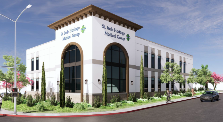
The 0.86 acre project site is located at the north west corner of Whittier Boulevard and Idaho Street. It is currently occupied by a vacant building that was previously occupied by Petco. The property is zoned C-2 Commercial, which is consistent with the General Plan Land Use Designation of Highway Commercial. This site is part of the integrated commercial center know as the La Habra Town Center. The project consists of the demolition of the existing commercial structure and the construction of a new two-story, 20,000 square foot medical office building (10,000 square-feet floor area for each level). The business hours will be Monday through Saturday from 8:00 a.m. to 5:00 p.m. The total staff, including physicians, would typically number around 41-42 individuals.
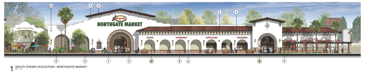
The building's architecture will mimic the architecture of the center, as depicted below.
The proposed structure and its placement on the site complies with the applicable development standards. This includes the placement of landscaping along the street frontages and reconfiguration of the parking lot to improve circulation and public safety (i.e., the placement of the building and the improvement to the driveway throat will improve visibility for cars exiting onto Whittier Boulevard [see attachment 5, Project Plans]). The landscape pallette matches with the overall planting scheme for the town center.
There are two aspects of the project that do not comply with the development standards as a stand-alone site and must rely on integration into the center to work. These are in the areas of parking and floor area ratio (FAR). The FAR is the measurement of a building's floor area in relation to the size of the lot that the building is located on. FAR is expressed as a decimal number and is derived by dividing the total area of the building by the total area of the parcel (building area ÷ lot area). For this project, the FAR is 30% which means the maximum square footage of a building can only be 30% of the lot area. Since the lot area is approximately 37,461 square feet, 30% of that would allow for a maximum 11,238 square foot building (or only half of the size of the proposed building). The proposed 20,000 square foot building yields a 54% FAR which exceeds the 30% standard. To address the FAR issue the Applicant has created an amendment to the CC&Rs for this center that would tie this lot to the lot immediately north of the site, to create a combined lot size of 1.8 ac.(78,408 square feet), which would then allow for a maximum building FAR of approximately 23,522 square feet. The proposed 20,000 square foot building on a combined lot area of 78,408 now yields a FAR of 0.25 which complies with code. Also, the Applicant has filed an application for a Conditional Use Permit allowing for shared parking with the overall La Habra Town Center. A parking demand analysis was prepared by a certified traffic engineering firm (LLG), that concluded sufficient parking exists for all the uses in the center (see attachment 6).
ANALYSIS
The proposed project is before the Planning Commission pursuant to the La Habra Municipal Code (LHMC) Section 18.68.020 which requires a Design Review for any new building on a commercially zoned lot. In order to approve a design plan, all the following findings must be made pursuant to Section 18.68.050:
Lastly the proposed project complies with the requirements of CEQA. As noted above, the project has been determined to be exempt, under the type 32 in-fill exemption. To qualify a project must meet the following criteria:
The City has created a VMT tool (criteria/standard) for analyzing projects. The tool has a process that includes screening out projects that do not meet the minimum criteria for analysis. The first level (test) is number of vehicle trips. If a project causes less than 110 vehicle trips, per 10,000 square feet, a VMT analysis is not required. The proposed project causes 696 vehicle trips, it cannot be screened out. Since the proposed project does not meet this criteria, we proceed to the second level (test). The second level includes a list of project types that the City has already determined to be not significant, and requires no further analysis. The list includes medical office buildings that serve the local needs of the community. Therefore, this project would not require a VMT analysis and in this case the project's traffic impacts would be considered less than significant under CEQA.
Lastly, in order to meet the zoning code requirements for parking, the Applicant has filed a Conditional Use Permit application to utilize shared parking within the center since the subject parcel cannot meet the parking requirements on its own. Pursuant to section 18.14.060.D, a Conditional Use Permit may be approved for the joint use of parking facilities when the following conditions are met: 1) The outer boundaries of the properties upon which the uses are proposed, to which the application relates, shall be located within five hundred feet of each other unless shuttle service is provided between the sites. 2) The applicants shall show that there is no substantial conflict in the principal operating hours of the uses for which the joint use of off-street parking facilities is proposed, and 3) The parties involved shall provide an agreement for such joint use by a legal instrument approved by the City attorney as to form and content. These conditions have been met for this project. Additionally, as with all Conditional Use Permits the following findings must be made:
Code Compliance
The building's architecture will mimic the architecture of the center, as depicted below.
The proposed structure and its placement on the site complies with the applicable development standards. This includes the placement of landscaping along the street frontages and reconfiguration of the parking lot to improve circulation and public safety (i.e., the placement of the building and the improvement to the driveway throat will improve visibility for cars exiting onto Whittier Boulevard [see attachment 5, Project Plans]). The landscape pallette matches with the overall planting scheme for the town center.
There are two aspects of the project that do not comply with the development standards as a stand-alone site and must rely on integration into the center to work. These are in the areas of parking and floor area ratio (FAR). The FAR is the measurement of a building's floor area in relation to the size of the lot that the building is located on. FAR is expressed as a decimal number and is derived by dividing the total area of the building by the total area of the parcel (building area ÷ lot area). For this project, the FAR is 30% which means the maximum square footage of a building can only be 30% of the lot area. Since the lot area is approximately 37,461 square feet, 30% of that would allow for a maximum 11,238 square foot building (or only half of the size of the proposed building). The proposed 20,000 square foot building yields a 54% FAR which exceeds the 30% standard. To address the FAR issue the Applicant has created an amendment to the CC&Rs for this center that would tie this lot to the lot immediately north of the site, to create a combined lot size of 1.8 ac.(78,408 square feet), which would then allow for a maximum building FAR of approximately 23,522 square feet. The proposed 20,000 square foot building on a combined lot area of 78,408 now yields a FAR of 0.25 which complies with code. Also, the Applicant has filed an application for a Conditional Use Permit allowing for shared parking with the overall La Habra Town Center. A parking demand analysis was prepared by a certified traffic engineering firm (LLG), that concluded sufficient parking exists for all the uses in the center (see attachment 6).
ANALYSIS
The proposed project is before the Planning Commission pursuant to the La Habra Municipal Code (LHMC) Section 18.68.020 which requires a Design Review for any new building on a commercially zoned lot. In order to approve a design plan, all the following findings must be made pursuant to Section 18.68.050:
- The proposed plan is consistent with the City's General Plan.
- The proposed plan is consistent with the City's Zoning Ordinance.
- The proposed plan is in the best interest of the public health, safety, and welfare of the community.
- The nature of the proposed land uses and the design is appropriate for the proposed location and is compatible to the surrounding land uses and improvements.
- The project complies with all requirements of the California Environmental Quality Act (CEQA).
Lastly the proposed project complies with the requirements of CEQA. As noted above, the project has been determined to be exempt, under the type 32 in-fill exemption. To qualify a project must meet the following criteria:
- The project is consistent with the applicable General Plan designation and all applicable General Plan policies as well as with applicable zoning designation and regulations;
- The proposed undertaking will occur within the City limits on a project site of not more than five acres that is substantially surrounded by urban development;
- The project site has no value as habitat for endangered, rare, or threatened species;
- The approval of the project would not result in any significant effects relating to traffic, noise, air, or water quality; and,
- The site can be adequately serviced by all required utilities and public services.
The City has created a VMT tool (criteria/standard) for analyzing projects. The tool has a process that includes screening out projects that do not meet the minimum criteria for analysis. The first level (test) is number of vehicle trips. If a project causes less than 110 vehicle trips, per 10,000 square feet, a VMT analysis is not required. The proposed project causes 696 vehicle trips, it cannot be screened out. Since the proposed project does not meet this criteria, we proceed to the second level (test). The second level includes a list of project types that the City has already determined to be not significant, and requires no further analysis. The list includes medical office buildings that serve the local needs of the community. Therefore, this project would not require a VMT analysis and in this case the project's traffic impacts would be considered less than significant under CEQA.
Lastly, in order to meet the zoning code requirements for parking, the Applicant has filed a Conditional Use Permit application to utilize shared parking within the center since the subject parcel cannot meet the parking requirements on its own. Pursuant to section 18.14.060.D, a Conditional Use Permit may be approved for the joint use of parking facilities when the following conditions are met: 1) The outer boundaries of the properties upon which the uses are proposed, to which the application relates, shall be located within five hundred feet of each other unless shuttle service is provided between the sites. 2) The applicants shall show that there is no substantial conflict in the principal operating hours of the uses for which the joint use of off-street parking facilities is proposed, and 3) The parties involved shall provide an agreement for such joint use by a legal instrument approved by the City attorney as to form and content. These conditions have been met for this project. Additionally, as with all Conditional Use Permits the following findings must be made:
- The granting of the Conditional Use Permit will not be detrimental to the public welfare and will not unreasonably interfere with the use, possession and enjoyment of surrounding and adjacent properties and will not impair the character of the zone in which it is to be located.
- The subject site is physically suitable for the type of land use being proposed.
- The use is conditionally permitted within the subject zone and complies with the intent of all applicable provisions.
- The granting of the Conditional Use Permit is consistent with the General Plan.
Code Compliance
| Zoning Standards | Required | Proposed |
| Front Setback | 15 Feet | 20 Feet |
| Side Setback (Street) | 10 Feet | 10 Feet |
| Rear Setback | 25 Feet | 100+ Feet |
| Building Height | 50 Feet | 46’ 6” |
| Floor Area Ratio Stand Alone With Lot Tie |
0.30 FAR 0.30 FAR |
0.54 FAR 0.25 FAR |
| Parking City Code (Stand Alone) Demand Per Parking Study |
82 Spaces (As A Stand Alone Site) 408 (Entire Center) |
32 Spaces 483 Spaces |
| Landscaping (Street Setback) | 10 Feet | 10 Feet |
| Landscaping (Parking Lot) | 7% (1478 sq. ft.) | 12% (2680 sq. ft.) |
| Trash Enclosure | 1 Required | 1 Provided |
FISCAL IMPACT/SOURCE OF FUNDING:
No City resources/funding is required for this proposal.
NATIONAL POLLUTANT DISCHARGE ELIMINATION SYSTEM (NPDES):
The Applicant's proposal has been reviewed pursuant to the requirements of the City's National Pollutant Discharge Elimination System (NPDES) Municipal Permit, the Local Implementation Plan (LIP), and the Model Water Quality Management Plan (WQMP), Section 7.2. Since the proposal will constitute the disturbance of more than 5,000 square feet of soil, a Priority WQMP has been prepared. All work undertaken will be required to incorporate Best Management Practices (BMPs) as required by the WQMP.
GENERAL PLAN RELEVANCE:
The property is designated Highway Community by the General Plan. This designation is characterized by uses that are primarily related to and dependent upon the City's main arterials for access. This site is part of a large commercial center that includes a mix of retail and service uses and services the City at large. The inclusion of medical offices would be complementary to these uses and would afford patrons the opportunity to complete multiple tasks at one location.
This project implements Policies: LU2.5 Places Supporting the Quality of Life, LU 3.2 Places to Meet Daily Needs, LU 4.4 Design Review, LU 5.5 Revitalization of Obsolete and Underused Properties, LU11.1 Diversity of Uses, 11.5 Cohesive Development, LU11.6 Enhanced Design Character, LU11.7 Architecture and Site Design, and LU 12.1 Land Use Mix of the General Plan 2035.
This project implements Policies: LU2.5 Places Supporting the Quality of Life, LU 3.2 Places to Meet Daily Needs, LU 4.4 Design Review, LU 5.5 Revitalization of Obsolete and Underused Properties, LU11.1 Diversity of Uses, 11.5 Cohesive Development, LU11.6 Enhanced Design Character, LU11.7 Architecture and Site Design, and LU 12.1 Land Use Mix of the General Plan 2035.
Attachments
- 1. Environmental Assessment
- 2. Preliminary WQMP
- 3. Vicinity Map
- 4. Resolution DR 20-05
- 5. Resolution CUP 20-16
- 6. Color Elevation
- 7. Project plans
- 8. Landscape Plan
- 9. Parking Demand Study
- 10. Applications
- 11. Notice To Property Owners
- 12. PowerPoint