
| Item No. 1. | |
| MEETING DATE: September 14, 2020 |
|
| TO: | PLANNING COMMISSION |
| FROM: | ROY N. RAMSLAND JR., PLANNING MANAGER By: Roy N. Ramsland, Jr., Planning Manager |
| VIA: | ANDREW HO, DIRECTOR OF COMMUNITY AND ECONOMIC DEVELOPMENT |
| SUBJECT: | AMENDED ON 9/17/2020 Consideration of:
at 1400 South La Habra Hills Drive.
An Environmental Impact Report was prepared pursuant to the CEQA Guidelines. A Scoping Meeting was held on December 8, 2015, at the La Habra Community Center to solicit information and comments from interested parties on what information or areas of study should be included in the initial study. The Draft Environmental Impact Report was circulated for public review and comment on February 26, 2018, for a 45-day review period pursuant to Section 15072 of the CEQA Guidelines, which was extended by the City Council to end on May 10, 2018, Potential impacts were identified and analyzed in the Draft EIR Copies of the reports were made available at the Community Development public counter at City Hall, on the City website, and at the La Habra Branch of the Orange County Library system. The City received 141 comments on the Draft EIR from state and local agencies, tribal authorities, interest groups, and the public. Pursuant to the provisions of the (CEQA) Guidelines, Section 15088.5(a), the City determined that a thorough response to the comments received by the City during the public review period necessitated the inclusion of significant new information. The City circulated the “Partially Recirculated Draft EIR” for a 57-day review period beginning on November 22, 2019 and ending on January 17, 2020. Upon completion of the review period for the Partially Recirculated Draft EIR, the City of La Habra prepared responses to written comments that were received on the Draft EIR during the initial public review period as well as written comments received during the recirculation period that relate to the revised and recirculated portions of the Partially Recirculated Draft EIR. The Final Draft EIR including the revised technical studies, and responses to the comments were made available to the public for review on July 7, 2020 (see attachment 2. Rancho La Habra Specific Plan Final Environmental Impact report Volumes 1, 2 and 3).
|
RECOMMENDATION:
It is recommended that the Planning Commission review the information provided in and attached to this report, along with public testimony provided at the hearing, and direct staff to create a resolution(s) with its recommendation to the City Council regarding the approval or denial of:
- Certification of the Draft Environmental Impact Report;
- General Plan Amendment 18-01 to change the Land Use Designation from Open Space to Low Density Residential (0-8 units/acre) for Planning Areas 2, 3 & 4, and to Mixed Use 1 for planning area 5 of the Rancho La Habra Specific Plan;
- Amendment #3 to the La Habra Hills Specific Plan;
- The change in land use designation for Zone 18-01 from La Habra Hills Specific Plan to Rancho La Habra Specific Plan for the area occupied by the Westridge Golf Course;
- The adoption of the Rancho La Habra Specific Plan;
- The Vesting Tentative Tract Map 17845;
- The Design Review 18-01 through 18-05 for Rancho La Habra Specific Plan Areas 1, 2, 3, 4, 6, and 7; and:
- Development Agreement 18-01 for the Rancho La Habra Specific Plant at 1400 South La Habra Hills Drive.
DISCUSSION:
The project applicant, Lennar Homes, is requesting to change the land use designation and zoning of the Westridge Golf Course in La Habra from “Open Space” to “Residential” for the purpose of developing up to 448 residential units (277 single-family homes and 171 multi-family dwelling units) through the adoption of a Specific Plan for the proposed development. The Westridge Golf Course is a 151-acre privately owned property that is currently operating as an active golf course business that is open to the public. The property is located in the southwest corner of the City near the City’s southern boundary.
As part of the project proposal, included in the Development Agreement, Lennar is proposing to dedicate approximately 29 acres of land at the project site to the City, on which Lennar will construct a public park and public trail. In addition, Lennar is proposing to renovate the existing golf clubhouse building (which will be located on the dedicated park land) into a community center building and dedicate the facility to the City. Lennar is also requesting that the City, at a later date, consider approving the formation of a Community Facilities District (CFD) to assist with the financing for this project. A CFD is commonly referred to as a Mello-Roos District and is funded via a special tax that is attached to the tax bill of property owners within that CFD. If approved, and once started, the proposed residential housing project is anticipated to take approximately six years to complete. Site grading and preparation will last approximately two years and home building will take approximately four years to complete. A brief history about the project site and the proposed project is provided below.
The project site was originally part of the 915-acre West Coyote Hills oil field, which straddled the cities of La Habra and Fullerton, and was operated by the Chevron Corporation. In 1992, the City of La Habra adopted the La Habra Hills Specific Plan to create a master-planned community on the 380 acres of the former oil field located within the City limits. The La Habra Hills Specific Plan provided a development plan consisting of four residential neighborhoods totally 700 residential dwelling units, an 18-hole golf course, a 29.5-acre community park, and 2.6 acres of open space. The residential component of the La Habra Hills Specific Plan was ultimately built out with a total of 556 single family dwelling units, along with the Westridge Golf Course. The golf course has always been privately owned and operated and is open for use by the general public, along with its clubhouse, which has and can still be rented for private parties and events. The ownership group of the golf course has indicated that golf is no longer profitable since they contend that golf play is down and they desire to now sell the property for residential development.
In 2015, Standard Pacific Homes submitted applications to the City for the residential development of Westridge Golf Course. In 2016 Standard Pacific merged with Ryland Homes and become CalAtlantic. In 2017 Lennar, the current developer on this proposed project, acquired CalAtlantic. The environmental review process for this project started with scoping meetings in 2015, with the Draft EIR being released in 2018, followed by a partially recirculated Draft EIR released in 2019, and a Final EIR released in August 2020.
A number of applications for discretionary actions have been filed by the applicant for consideration as part of the approval process for this project. Each of the following applications for discretionary actions are listed below and discussed in greater detail in this report.
- General Plan Amendment 18-01 to change the land use designation from Open Space to Low Density Residential (0-8 units/acre) for Planning Areas 2, 3, and 4;
- Amendment #3 to the La Habra Hills Specific Plan to remove the golf course;
- Adoption of the Rancho La Habra Specific Plan;
- Zone 18-01 to change the land use designation from La Habra Hills Specific Plan to Rancho La Habra Specific Plan for the area occupied by the Westridge Golf Course;
- Vesting Tentative Tract Map 17845;
- Development Agreement 18-01; and
- Design Review 18-01 through 18-05 for Rancho La Habra Specific Plan Areas 1, 2, 3, 4, 6, and 7.
General Plan Amendment
The Applicant is requesting to amend the La Habra General Plan 2035 Land Use Designation for the existing Westridge Golf Course from “Open Space” to “Low Density (0-8 unit/acre) Residential” for Planning Areas 2, 3, and 4, and “Mixed Use 1” for Planning Areas 1 and 5, of the Rancho La Habra Specific Plan (RLHSP). Planning Area 6 which encompass the portions of the project that have been proposed to be dedicated as a new City park and trails, and Planning Area 7 which is the existing Westridge Residential Neighborhood Slope, would retain the “Open Space” designation, which would be consistent with the land uses proposed in the RLHSP. Since this development proposal is not consistent with the La Habra Hills Specific Plan Zoning Designation, the applicant has also requested a change in zoning by removing the site from the La Habra Hills Specific Plan and creating the new RLHSP.
In addition, the applicant's request would require text amendments to the City’s General Plan. These modifications would include increasing the maximum number of housing units, deleting references to the golf course, and referencing the proposed Rancho La Habra Specific Plan.
Amendment to La Habra Hills Specific Plan
The development proposal includes a revision to the boundary of La Habra Hills Specific Plan (LHSP) by removing the 151-acre golf course from the Plan. The La Habra Hills Specific Plan was originally adopted by the La Habra City Council on March 23, 1992. The Plan was later amended by the La Habra City Council on November 14, 1994, and again on June 5, 1997. The 1994 amendment modified the circulation of the Plan’s Phase II developments by eliminating a new intersection on Beach Boulevard (Ordinance 1483). The 1997 Amendment adopted the “alternate” development plan which eliminated Planning Area B that would have allowed for 100 multi-family residential units and reconfigured Planning Area C. The adopted Plan originally contemplated a relocation of the corporate boundary between the City of La Habra and the City of Fullerton (Ordinance 1510).
The removal of the golf course also necessitates map and text amendments to the LHSP to adjust the land use numbers and other changes to make it internally consistent along with removing all references and conditions related to the golf course (see La Habra Hills Specific Plan Amendment #3, Appendix B of the FEIR). In addition, the applicant is requesting the California Department of Fish and Wildlife to vacate its existing deed restrictions that were previously established on the Project site and to approve a new Streambed Alteration Agreement. These deed restrictions within the project site were established as mitigation for impacts related to previous construction of the existing golf course and adjacent residential areas to the south pursuant to the La Habra Hills Specific Plan.
Adoption of Rancho La Habra Specific Plan
The proposed project would require a zone change for the golf course property from the La Habra Hills Specific Plan to the Rancho La Habra Specific Plan. The Rancho La Habra Specific Plan proposes a residential community with a mix land use that includes single-family residential, multi-family residential, a commercial option, recreation, and open space. The plan defines the density, design guidelines and development standards along with the circulation patterns, and the infrastructure necessary to adequately serve the proposed land uses.
The Specific Plan is divided into seven planning areas with land uses described below in Table 1. The Plan is graphically depicted in Figure 6 of the Rancho La Habra Specific Plan (see Rancho La Habra Specific Plan, Appendix C of the FEIR). The land use breakdown and sizes are described in Tables 1 and 2 below.
Table 1. Planning Area Land Use
| Planning Area | Planning Area Use | Land Use Designation |
| PA 1 | Multi-Family Residential | Multi-Family 1 |
| PA 2 | Single Family Residential | Low Density Residential |
| PA 3 | Single Family Residential | Low Density Residential |
| PA 4 | Single Family Residential | Low Density Residential |
| PA 5 | Commercial or Multi-Family Residential | Mixed-Use Center 1 |
| PA 6 | Public Open Space/ Parkland Conservation District Overlay |
Open Space |
| PA 7 | Existing Westridge Residential Neighborhood Slope | Open Space |
Planning Areas 1 through 4 provide a maximum of 402 dwelling units resulting in an overall gross density of 2.66 dwelling units per acre (du/ac). If PA 5 is developed as residential, a maximum of 448 dwelling units would be provided, resulting in an overall gross density of 2.97 dwelling units per acre (du/ac). This overall density is consistent with City’s Low Density (0 – 8 dwelling units per acre) Land Use Designation.
Table 2. Use by Planning Area
| Use | Acres | ||||||||
| PA 1 | PA 2 | PA 3 | PA 4 | PA 5 | PA 6 | PA 7 | Total | Percentage | |
| Conservation Area | - | - | - | - | - | 9.86 | - | 9.86 | 6% |
| Public Open Space and Parkland | - | - | - | - | - | 28.86 | - | 28.86 | 19% |
| Private Open Space and Detention Basins1 | 1.66 | 14.5 | 5.86 | 5.91 | .14 | - | - | 28.07 | 19% |
| Existing Westridge Slope | - | - | - | - | - | - | 19.38 | 19.38 | 13% |
| Multi-Family Residential | 8.6 | - | - | - | - | - | - | 8.6 | 6% |
| Single Family Residential | - | 14.2 | 7.90 | 12.5 | - | - | - | 34.6 | 23% |
| Retail or Multi-Family Residential | - | - | - | - | 2.50 | - | - | 2.50 | 2% |
| Roads | 0.3 0 | 6.98 | 3.10 | 5.18 | - | 3.41 | - | 18.97 | 12% |
| Total | 10.5 6 | 35.68 | 16.86 | 23.59 | 2.64 | 42.13 | 19.38 | 150.84 | 100% |
| Dwelling Units | 12 5 | 118 | 77 | 82 | NA / 46 | NA | NA | 402 / 448 | - |
| 1. Private open space consists of private park spaces available only to the Rancho La Habra residents, which includes pools and passive park spaces, privately maintained open space and slopes, and detention basins. 2. PA5 provides for either 46 multi-family dwelling units or 20,000 square feet of retail and/or restaurant uses. Assuming development of the 20,000 square feet of retail, the total number of dwelling units would be 402. Assuming no retail uses, the total number of dwelling units would be 448. |
|||||||||
Planning Area 1:
This area consists of 125 multi-family dwellings (for sale) located in 26 buildings. There are five building types (A through E). Building A is a two-plex, Building B is a four-plex, Buildings C and D are a five-plex and Building E is a six-plex. Each building contains a mix of three and four-bedroom units with four different unit configurations ranging from 1,601 square feet to 2,058 square feet.
The units are designed with living area facing the common areas, such as paseos or sidewalks. Each unit includes an attached two-car garage. The massing and scale of the buildings have been articulated to provide individual elevation elements in a balanced and aesthetically pleasing way. Walkable courts and outdoor patios provide building separation and also soften massing. The structures also incorporate a mix of three architecture styles: Italian, Monterey, and Spanish to provide variety within the neighborhood and provide visual interest (see architectural, and site for Planning Area 1 through 4 and 6, attachment 19).
In addition to the garages, 252 uncovered parking spaces are provided; 58 in driveways and 194 for guests. Each unit has private open space ranging from 80 to 131 square feet located in patios, decks and yards. The recreation area is 8,493 square feet and consists of a building and a pool. Within the Planning Area there is 139,272 square feet of common open space and landscaping for a total of 168,962 square feet (3.9 acres) of open space, or 37% for the entire planning area.
Planning Areas 2 through 4 Overview:
These areas incorporate the same basic design principles and guidelines as detailed in Chapter 5 of the Rancho La Habra Specific Plan (see Rancho La Habra Specific Plan, Appendix C of the FEIR). Each planning area is gated, has private streets, private yards, common open space and landscaping, and a common recreational facility. The private streets include a sidewalk in front of each home and a street tree program mandates the installation and ongoing maintenance of street trees placed behind the sidewalk in order to provide shaded sidewalks to encourage walking.
The homes have a combination of front-loaded and side-loaded garages. All garages maintain a minimum 18-foot driveway measured from the face of the garage to the back of the sidewalk. Side-entry garages extend up to ten feet from the property line, however; a minimum of 24 feet of backing distance is maintained, thereby providing two off-street parking spaces for each home.
The homes and lots are configured so that no plan is located side by side or directly across from each other with the same elevation. Additionally, the elevations and color schemes of the homes are mixed throughout the neighborhoods to make sure that no home of the same plan and elevation on a single street shall be the same.
The homes in each planning area incorporates a mix of architecture which includes Adobe Ranch, Andalusian, Monterey, Santa Barbara, Spanish and Tuscan. Where homes abut or are visible from the main road in the Specific Plan Area, they have been provided with enhanced elevation(s) on the side(s) or rear facing the road. Enhancement elements may include: window enhancements using shutters and pot shelves, balconies with decorative iron rail, window trim, and color and material enhancements where architectural style permits (see Attachment, Project Design Plans).
All front yard landscaping in PA 2, 3, and 4, will be installed by the developer and maintained by the homeowner. The community will have Covenants, Conditions & Restrictions (CC&R’s) in place with detailed guidelines for the homeowners pertaining to maintenance and changes to front yard landscape. Each lot will have a designated street tree, which will be installed by the developer, and maintained by the individual homeowner in accordance with guidelines specified in the CC&Rs.
The species of each street tree will be specified on the final landscape plans and the CC&R’s will have specific guidelines on how to maintain and irrigate the street trees. Front yard landscaping will minimize or eliminate the use of turf and include a variety of shrub and patio tree species to create a layering effect with different sizes, textures, and colors of plant material. The project has been conditioned so that the final landscape plans will be submitted to City planning staff for review prior to the recordation of the CC&R’s and issuance of any building permits.
Planning Area 2:
This area consists of 118 single family lots with minimum lots sizes of 48 feet by 80 feet. It provides a recreation area/facility located on “N” Street, south of lot 238. The facility provides a swimming pool and spa, restrooms and showers, barbeque and picnic facilities, and a shade structure. Further south of the facility, it is connected to the public trail system from “N” Street, east of lot 244, via lettered lot “PP.”
The homes in this PA utilize three plan types each with three architectural options: Tuscan, Spanish, and Monterey. Each plan type has three variations. The dwellings range in size from 2,651 square feet to 2,916 square feet. Each plan type has the different color palette options.
Table 3. Planning Area 2 Plan Types
| Plan type | Number of Units | Sq. Ft. | Garage Spaces | Description |
| 1 | 35 | 2,651 | 2 | 4 Beds, 3 Baths, Loft |
| 2 | 40 | 2,804 | 2 | 4 Beds, 4.5 Baths, Bonus room |
| 3 | 43 | 2,916 | 3 | 4 Beds, 3.5 Baths, Bonus room/Opt. Bed 5 |
| Total | 118 |
Additionally, the model complex for both PA 2 and PA 3 is located in this planning area. The complex is located on lots 248 through 255. Lots 248-250 are the models for PA 2, lots 253, 254 & 255 are the models for PA 3, and Lots 251-253 contain a temporary sales office (modular trailer) and 16 parking spaces; these lots will ultimately be developed with homes of the PA 2 designs. A conditional use permit application for the model homes will be considered at a future date.
Planning Area 3:
This area consists of 77 single family lots with minimum lots sizes of 47 feet by 70 feet. It provides a recreation area/facility located on “C” Street, south of lot 83. This facility includes a swimming pool, wading pool and spa, restrooms and showers, barbeque and picnic facilities, and a shade structure. This facility, while located in PA 3, is shared by PA 4 which has access from “F” Street, south of lot 82. From this facility both PAs have access to the public trail system. The homes in this PA utilize three plan types, each with three architectural options: Santa Barbara, Monterey and Adobe Ranch. Each plan type has three variations. The dwellings range in size from 2,370 square feet to 2,672 square feet.
Table 4. Planning Area 3 Plan Types
| Plan type | Number of Units | Sq. Ft. | Garage Spaces | Description |
| 1 | 24 | 2,370 | 2 | 4 Beds, 3 Baths, |
| 2 | 25 | 2,472 | 2 | 4 Beds, 3 Baths, Loft |
| 3 | 28 | 2,671 | 2 | 4 Beds, 3 Baths, Bonus room |
| Total | 77 |
Planning Area 4:
This area consists of 82 single family lots with minimum lot sizes of 55 feet by 90 feet. As noted above it shares the recreation area with are PA3. The homes in this PA utilize three plan types, each with architectural options: Formal Spanish, Tuscan and Andalusian. Each Plan type has three variations. These units range in size from 3,023 square feet to 3,712 square feet.
Table 5. Planning Area 4 Plan Types
| Plan type | Number of Units | Sq. Ft. | Garage Spaces | Description |
| 1 | 26 | 3,023 | 3 | 4 Beds, 3.5 Baths, Bonus room/Opt. Bed 5 |
| 2 | 27 | 3,385 | 3 | 4 Beds, 4.5 Baths, Den, Bonus room/Opt. Bed 5 |
| 3 | 29 | 3,712 | 3 | 5 Beds, 4.5 Baths, Bonus room |
| Total | 82 |
Planning Area 5
As noted in Table 2 “Use by Planning Area”, this area allows for either a residential component with 46 units (which is the applicant’s preferred alternative) or development of a maximum of 20,000 square feet of commercial uses (i.e. commercial/retail stores, restaurants, grocery, etc.). The plan submitted as part of this application shows both options. The design of the residential units matches those of PA 1.
Planning Area 6
This area retains the General Plan designation of Open Space and includes 42.13 acres of area. The area is subdivided into 28.86 acres of public Open Space, consisting of public park and recreation facilities that will be built/renovated and then dedicated to the City, 9.86 acres of Conservation Area, and 3.41 acres of roads. The descriptions of each area and amenities are provided below and depicted in Figure 7 of the Rancho La Habra Specific Plan (see Appendix C of the FEIR).
Public Community Center and Parking Lot – 3.3 acres
- If this project is approved, the existing Westridge Golf Course clubhouse will be renovated and then deeded to the City, consisting of an approximately 22,500 square foot structure providing indoor banquet, dining, kitchen, meeting, recreational, and office facilities
- Outdoor banquet, dining, gathering space
- Covered lounge with fire pit
- Media wall (T.V.)
- Soft seating on patios
- Bike racks
- Event lawn and amphitheater
- Adventure play area and open turf
- Public parking lot
Public Park and Picnic Area – 12.79 acres.
- An extension of the renovated Community Center building and park to the south
- Terraced multi-purpose turf play areas
- Picnic areas with shade trees and views of the La Habra valley, hills and San Gabriel Mountains
Public Linear Park – 12.77 acres
- 2.6 miles of trails looping throughout the entire community with access to Idaho Street, and Beach Boulevard, regional trails, and Westridge Plaza Shopping Center
- Benches and shade trees
- Viewing overlooks along and above the trail for views of the San Gabriel Mountains
- Exercise equipment
Public Streets – 3.41 acres
Conservation Area – 9.86 acres
Conservation Area – 9.86 acres
- This area includes a mix of preserved and installed coastal sage scrub habitat
Planning Area 7:
This area consists of 19.38 acres of existing landscaped slope along the north edge of the Westridge residential neighborhood. It is graphically depicted on Figure 7 of the Rancho La Habra Specific Plan (see Figure 7 of the Rancho La Habra Specific Plan. Appendix C of the FEIR).
Other Approvals and Entitlements
The Applicant’s proposal also includes a number of actions necessary for the development and implementation of the project. These include the following:
- Approval of a Vesting Tentative Tract Map;
- The release and revocation of the existing deed restrictions (Conservation Areas) from the California Department of Fish and Wildlife (CDFW); and,
- Approval of a Development Agreement with the City; a provision in the Development Agreement requests that the City consider formation of a CFD, which would be subject to a separate discretionary approval process.
Vesting Tentative Tract Map:
The Vesting Tentative Tract Map is the instrument that divides the project site into 358 parcels for the development of the proposed homes and other improvements. In addition to the lots for the homes described above, lots have been created for an Underground Detention Basin, Entry Gates/Roads, the Clubhouse, Open Spaces, and Streets. The approval of a vesting map confers a vested right to proceed with development in substantial compliance with the ordinances, policies, and standards in effect at the time the vesting map is deemed complete. The vested rights do not get conferred unless the Final Map is approved by the City Council and the Council would not be able to approve a Final Map unless CDFW releases existing deed restrictions.
Deed Restrictions (Conservation Areas) – California Department of Fish and Wildlife:
For this project to proceed as proposed, it will be necessary for the applicant to receive approval from the California Department of Fish and Wildlife (formerly the Department of Fish and Game) to vacate the existing deed restrictions on site and approve a new streambed alteration agreement. There currently exists approximately 9.86 acres of “Conservation Area” distributed in various locations within the current golf course. As part of the regulatory approval process for construction of the existing golf course, a deed restriction was recorded as mitigation for impacts to 4.55 acres of mulefat scrub as a result of the Phase II development of the La Habra Hills Specific Plan. The deed restriction was created to protect these mitigation areas in perpetuity.
The deed restriction is included as part of the Section 1603 Agreement (dated May 30, 1995) issued by the then California Department of Fish and Game (File No. 5-465-94). The applicant for the proposed Rancho La Habra Specific Plan is requesting that the California Department of Fish and Wildlife vacate the existing deed restriction in return for onsite habitat protection as well as purchase and preservation of habitat at one or more offsite locations described in the Final EIR. The proposed Rancho La Habra Specific Plan includes 14.3 acres of conservation area. Should the City approve the proposed project, no permitting or construction could occur for the proposed project until the existing deed restriction has been vacated and new streambed alteration agreement is approved by the California Department of Fish and Wildlife and implemented. Additionally, the Final Vesting Tract Map could also not be approved until a new streambed alteration agreement has been reached by the applicant with the California Department of Fish and Wildlife. On August 19, 2020, the California Department of Fish and Wildlife provided the City with an email concurring with the biological resources mitigation requirements outlined in the Final EIR.
Development Agreement:
Lastly, as part of the proposed project, the Developer has proposed to enter into a Development Agreement with the City. A Development Agreement is a binding legal contract between a city and a developer that establishes a commitment whereby the city agrees to permit the project applicant or its successors to develop the proposed project under the agreed-upon terms, and commits the applicant to the provision of specified public benefits or improvements.
The main deal points of the proposed agreement are that over the term of 15 years the applicant (Lennar) retains development rights and, in exchange, provides the following community benefits to the City:
- The land dedication of approximately 29 acres of public park, trails, and community center that will be deeded to the City once complete, which the applicant estimates has an approximate value of $19.5 million;
- The construction of a new park, trails, renovation of the existing clubhouse into a community center and other street and off-site improvements that will be deeded to the City once complete, which the applicant estimates has an approximate value of $18 million;
- A payment of $1,500,000 as a public benefit contribution to be used as determined by the City Council; and
- A payment of $1,000,000 as an affordable housing contribution to be used by the City to facilitate future affordable housing developments;
The Development Agreement also includes a request that the City consider forming a CFD. This proposal would be subject to a separate discretionary approval process. If approved, the CFD may be used to fund construction of the infrastructure described in the Specific Plan such as public roads, sewers, and other infrastructure necessary for the project, renovations to the golf clubhouse in order to convert it into a new community center building, construction of the public park and trails, and to fund the continued annual maintenance of the public parks, community center facility, public parking lot, and medians on the project site.
The total estimated value of the land and assets that will be constructed and dedicated to the City, in addition to the cash payments for discretionary community benefit projects and affordable housing developments, is approximately $40 million.
Implementation
The total estimated value of the land and assets that will be constructed and dedicated to the City, in addition to the cash payments for discretionary community benefit projects and affordable housing developments, is approximately $40 million.
Implementation
If this proposed development project is approved by the City Council, the applicant will begin clearing and grading the project site, which will take approximately one year, and will include the removal of a large parking lot, golf cart paths, maintenance yard, and driving range. Infrastructure improvements, including storm drains, water and sewer mains, and streets, would be installed over an approximately 9 to 12-month period following grading. Construction of homes in each residential Planning Area would occur in increments based on market demand. Planning Areas 2, 3, and 4 would be constructed in increments of 6 to 10 homes at a time. For residential Planning Area 1, development increments would generally consist of two multi-family buildings (approximately 10 to 12 dwelling units) being constructed at a time. Buildout of the entire project site is anticipated to occur over a six-year period.
ANALYSIS:
DISCUSSION/ANALYSIS
Pursuant to the California Environmental Quality Act (CEQA), an Environmental Impact Report (EIR) was prepared for this project. The purpose of CEQA and the EIR is to inform decision makers about significant environmental effects, and identify ways to avoid or minimize those significant environmental effects.
The environmental documentation process for Rancho La Habra started with a scoping meeting on December 8, 2015, at the La Habra Community Center to solicit information and comments from interested parties on what information or areas of study should be included in the initial study.
The Draft Environmental Impact Report (DEIR) was circulated for public review and comment on February 26, 2018, for a 45-day review period, which was then extended by the City Council to end on May 10, 2018. Potential impacts identified and analyzed in the Draft EIR include, Land Use and Planning, Population and Housing, Aesthetic Resources, Biological Resources, Cultural Resources, Traffic and Circulation, Air Quality, Greenhouse Gas Emissions, Energy Resources, Noise and Vibration, Hazards and Hazardous Materials, Hydrology and Water Quality, Geology, Soils, and Seismicity, Public Services, Recreation, Utilities, Service Systems, and Water Supply. The DEIR is provided in Final EIR Volume 1.
The City received 141 comments on the Draft EIR from state and local agencies, tribal authorities, various interest groups, and the general public. In preparing responses to these public comments, new information included:
- Modifications to the Project Description that were proposed by the applicant subsequent to the close of the public review period for the Draft EIR that modified the design of the proposed community center and adjacent park, requiring revisions to the project’s biological resources impact analysis.
- New biological resources surveys, updated mapping and impact analysis, and an updated mitigation program that were prepared to address CDFW’s comments on the Draft EIR, along with an updated impact analysis addressing the modified design of the proposed community center and adjacent park. The updated biological resources analysis also included updating the mapping of vegetation communities to characterize vegetation alliances in accordance with The Manual of California Vegetation, Second Edition (Sawyer et al. 2009).
- An updated traffic impact analysis, which indicated that the project would generate a substantially greater net increase in daily traffic than was originally determined in the Draft EIR and that new significant unavoidable impacts would occur at intersections in addition to those disclosed in the Draft EIR. The updated traffic impact analysis was based on updated traffic counts and updated traffic generation based on the 10th Edition of Trip Generation, published by the Institute of Transportation Engineers (ITE) (Washington D.C. 2012).
- Updated air quality, greenhouse gas (GHG), energy, and noise analyses that were prepared to reflect the increase in daily traffic generation indicated in the updated traffic impact analysis. The updated air quality and GHG analyses used the most recent California Emissions Estimator ModelTM (CalEEMod) v2016.3.2 and the 2017 version of the Emission Factor model (EMFAC) developed by the California Air Resources Board (CARB), both of which became available subsequent to preparation of air quality and GHG studies for the Draft EIR. The updated air quality, GHG, energy, and noise analyses also reflect slight revisions to construction scheduling proposed by the Applicant subsequent to the close of the Draft EIR public review period.
The new information resulted in the “Partially Recirculated Draft EIR” which was circulated for a 57-day review period beginning on November 22, 2019, and ending on January 17, 2020. The Partially Recirculated Draft EIR is provided as Final EIR Volume 2. Upon completion of the review period for the Partially Recirculated Draft EIR, the City prepared responses to written comments that were received on the Draft EIR during the initial public review period, as well as to written comments received during the recirculation period that relate to the revised and recirculated portions of the Partially Recirculated Draft EIR (see Final EIR, Volume 3). The Final Draft EIR including Draft EIR (Volume 1), Partially Recirculated Draft EIR (Volume 2), technical appendices, and responses to the comments (Final EIR, Volume 3) were made available to the public on the City’s website on July 20, 2020.
The Final EIR is composed of the following documents:
The Final EIR is composed of the following documents:
- Volume 1
- Draft EIR and Appendices (February 2018), for those portions of the Draft EIR not superseded by the Partially Recirculated Draft EIR and its Appendices (November 2019);
- Additional revisions to the text and figures of the Draft EIR, generated either from responses to comments or independently by the City, have been incorporated into this volume of the Final EIR in an underline – strikeout format; and
- Mitigation Monitoring and Reporting Program (MMRP) for those environmental issues not addressed in the Partially Recirculated Draft EIR.
- Volume 2
- Partially Recirculated Draft EIR and Appendices (November 2019);
- Additional revisions to the text and figures of the Partially Recirculated Draft EIR, generated either from responses to comments or independently by the City, have been incorporated into this volume of the Final EIR in an underline – strikeout format; and
- Mitigation Monitoring and Reporting Program (MMRP) for those issues addressed in the Partially Recirculated Draft EIR.
- Volume 3
- Responses to Comments
- Complete Mitigation Monitoring and Reporting Program (MMRP)
Environmental Impact Report (SCH No. 20151110945)
The EIR identified the following significant and unavoidable impacts that would result from development permitted by the proposed Specific Plan for those environmental issues addressed in the Draft EIR as modified by the Partially Recirculated Draft EIR.
Land Use and Planning:
The proposed Specific Plan would be inconsistent with a goal and several policies of the Southern California Association of Governments (SCAG) 2016 Regional Transportation Plan/Sustainable Communities Strategy (RTP/SCS) related to reducing reliance on single occupant automobile travel and concentrating future development into higher density transit-oriented locations. Since these inconsistencies are reflected in significant unavoidable air quality, greenhouse gas (GHG), and traffic impacts, impacts related to inconsistencies with the 2016 RTP/SCS would be significant even with implementation of all feasible mitigation measures. Impacts would therefore be significant and unavoidable.
Population and Housing:
Implementation of the proposed Rancho La Habra Specific Plan would generate population growth as the direct result of the housing proposed by the new Specific Plan. While the proposed project would not necessarily increase the City’s projected growth rate through 2040, it would substantially increase La Habra’s inventory of land for the development of housing, and therefore result in substantial population growth. The resulting impact would be significant and unavoidable.
Aesthetics:
Implementation of the proposed Rancho La Habra Specific Plan would result in the loss of a major open space resource and recreational golf amenity. While the proposed project is low density and well planned and designed, the substantial loss of open space that would result from project development would degrade the existing visual character of the site. Even with implementation of project design features, such as dedication of public open space (a park and trails), and compliance with existing regulations, housing rather than open space would constitute the predominant visual feature of the site. This impact would therefore be significant and unavoidable.
Traffic and Circulation:
The FEIR conducted the several analyses including but not limited to;
- Existing Traffic Conditions
- Existing Conditions + Proposed Project Traffic
- Future Traffic + Traffic from Cumulative Projects
- Future + Cumulative Projects + Proposed Project
The applicant is required to fully pay for improvements within City-limits at the project’s entries and City traffic impact mitigation fees. Should such fees be insufficient to cover the applicant’s fair share of the actual cost of needed physical improvements, the Final EIR requires the applicant to pay for the project’s shortfall.
With respect to mitigation at intersections under the jurisdiction of the cities of Fullerton, Buena Park, and La Mirada, along with Caltrans owned intersections, under CEQA, a fair share monetary contribution is considered to be adequate mitigation only if the fee is tied to improvements that the relevant agency is committed to implementing. However, staff has confirmed that these cities and Caltrans do not have mitigation fund programs in place for improvements to which the proposed project can contribute. Therefore, although the Final EIR requires the applicant to make fair share mitigation payments to the cities of Fullerton, Buena Park, and La Mirada and Caltrans, the City of La Habra has no authority to require these agencies to accept the fair share fees and permit the improvements identified in the Final EIR to actually be constructed. The City of La Habra will therefore work with the cities of Fullerton, Buena Park, and La Mirada and Caltrans with the goal of having the project’s fair share mitigation payments to these agencies accepted so that the needed improvements can be made. CEQA requires that because the City of La Habra cannot guarantee physical construction of improvements at intersection not under La Habra’s jurisdiction, traffic impacts would be significant and unavoidable. See Table ES-3 below for a summary of traffic impacts at specific intersections.
With respect to mitigation at intersections under the jurisdiction of the cities of Fullerton, Buena Park, and La Mirada, along with Caltrans owned intersections, under CEQA, a fair share monetary contribution is considered to be adequate mitigation only if the fee is tied to improvements that the relevant agency is committed to implementing. However, staff has confirmed that these cities and Caltrans do not have mitigation fund programs in place for improvements to which the proposed project can contribute. Therefore, although the Final EIR requires the applicant to make fair share mitigation payments to the cities of Fullerton, Buena Park, and La Mirada and Caltrans, the City of La Habra has no authority to require these agencies to accept the fair share fees and permit the improvements identified in the Final EIR to actually be constructed. The City of La Habra will therefore work with the cities of Fullerton, Buena Park, and La Mirada and Caltrans with the goal of having the project’s fair share mitigation payments to these agencies accepted so that the needed improvements can be made. CEQA requires that because the City of La Habra cannot guarantee physical construction of improvements at intersection not under La Habra’s jurisdiction, traffic impacts would be significant and unavoidable. See Table ES-3 below for a summary of traffic impacts at specific intersections.
Table ES-3
Summary of Significant Unavoidable Traffic Impacts
Summary of Significant Unavoidable Traffic Impacts
| Jurisdiction | Significant Impact? | Included in Fee Program? | Can La Habra Independently Implement Mitigation? | Included in Fair Share? | Level of Significance | ||
| Intersections | |||||||
| 1. | Beach Boulevard at Rosecrans Avenue | La Mirada/Caltrans | Yes | No | No | Yes | SU |
| 10. | Beach Boulevard at Imperial Highway | La Habra/Caltrans | Yes | No | No | Yes | SU |
| 13. | Euclid Street at Imperial Highway | La Habra/Caltrans | Yes | No | No | Yes | SU |
| 14. | Harbor Boulevard at Imperial Highway | La Habra/Caltrans | Yes | No | No | Yes | SU |
| 15. | Beach Boulevard at Lambert Road | La Habra/ Caltrans | Yes | No | No | Yes | SU |
| 20. | Beach Blvd at La Mirada Blvd/Malvern Ave | Buena Park/ Caltrans | Yes | No | No | Yes | SU |
| 23. | Beach Boulevard at Artesia Boulevard | Buena Park/ Caltrans | Yes | No | No | Yes | SU |
| 29. | Hacienda Road at Whittier Boulevard | La Habra/ Caltrans | Yes | No | No | Yes | SU |
| Roadway Segments | |||||||
| M. | Imperial Highway between Euclid Street and Harbor Boulevard | La Habra/Caltrans | Yes | No | No | No | SU |
| X. | Beach Boulevard between Rosecrans Ave and La Mirada Blvd | Buena Park/Caltrans | Yes | No | No | No | SU |
| Freeway Mainline Segments | |||||||
| SR-57 southbound north of Imperial Hwy | Caltrans | Yes | No | No | No | SU | |
| Freeway Merge-Diverge Movements | |||||||
| SR-57 southbound on-ramp (EB) from Imperial Hwy | Caltrans | Yes | No | No | No | SU | |
| Left Turn Queueing | |||||||
| 10. | Beach Boulevard at Imperial Highway | La Habra/Caltrans | Yes | No | No | Yes | SU |
Notes: LTS = Less than Significant; SM = Significant but Mitigable; SU = Significant and Unavoidable
The proposed project would generate approximately 4,347 additional vehicle trips during A.M. and P.M. peak hours more than the golf course, with a net increase of 330 additional trips in the morning and 419 trips in the evening. Generally, this represents an increase of approximately three to four percent at various road segments within the City.
Lastly, pursuant to CEQA regulations, LOS methodology was utilized because the Notice of Preparation (NOP for the project’s EIR was issued prior to December 2018). In July 2020, new projects are required to conduct vehicle miles traveled (VMT) analysis. In general LOS analyses traffic congestions (delay). VMT analysis looks at total miles travel and is used to compare a project’s impact related to greenhouse gas and air quality. The proposed project did analyze VMT in greenhouse gas and air quality technical reports.
Lastly, pursuant to CEQA regulations, LOS methodology was utilized because the Notice of Preparation (NOP for the project’s EIR was issued prior to December 2018). In July 2020, new projects are required to conduct vehicle miles traveled (VMT) analysis. In general LOS analyses traffic congestions (delay). VMT analysis looks at total miles travel and is used to compare a project’s impact related to greenhouse gas and air quality. The proposed project did analyze VMT in greenhouse gas and air quality technical reports.
Air Quality:
Although the proposed project would not result in an increase in the frequency or severity of existing air quality violations or cause or contribute to new violations, the project’s increased housing and population growth would be inconsistent with the Air Quality Management Plan for the South Coast Air Basin since the project-related traffic and air pollutant emissions are not accounted from the regional air quality management plan.
Greenhouse Gas Emissions:
The proposed Rancho La Habra Specific Plan would result in a net increase in GHG emissions of 7,554.69 million tons of carbon dioxide equivalent (MTCO2e) per year, which is the standard measurement for greenhouse gas emissions. This would exceed the SCAQMD’s screening threshold of 3,000 MTCO2e per year. In addition, because the project would introduce increased housing in an area without major public transit and would increase reliance on the use of automobile travel, it is inconsistent with three goals and one policy of the regional transportation plan and sustainable communities strategy required by state law to reduce greenhouse gas emissions. By constructing single family housing in an area that is without major transit, the project would be reliant on automobile travel.
Although Mitigation Measures GHG-1a, GHG-1b, GHG-1c, GHG-1d, GHG-1g, GHG-1h, and GHG-1i would achieve consistency with the City’s Climate Action Plan and the California Air Resources Board (CARB) 2017 Scoping Plan, the Project would introduce increased housing in an area without major public transit and would increase reliance on the use of automobile travel, and will be inconsistent with three goals and one policy of the regional RTP/SCS.
NOISE
Project-related demolition and crushing, site grading, and infrastructure and building construction would temporarily expose persons to noise levels substantially in excess of existing conditions. Even with implementation of mitigation measures, construction noise levels would remain substantially above ambient conditions and would be clearly audible to area residents.
Despite the existence of these significant unavoidable impacts, CEQA permits the City to approve the proposed project if it finds that specific economic, legal, social, technological, or other benefits of the project to the community outweigh the unavoidable adverse environmental effects. Should the Planning Commission wish to recommend that the City Council approve any of the discretionary actions requested by the applicant, it must consider the Final EIR and recommend that the City Council certify the Final EIR as meeting CEQA requirements along with adoption of a “Statement of Overriding Considerations,” outlining the specific economic, legal, social, technological, or other benefits of the project to the community outweigh the unavoidable adverse environmental effects.
Should the Commission recommend denial of the land use changes and discretionary approvals, no certification of the EIR would be required.
General Plan Amendment
The City’s General Plan 2035, which was adopted on January 21, 2014, did not contemplate this type of project for this site. The long-range vision for this property, as indicated in the General Plan, is open space. The Vision Statement in the General Plan discusses who the City of La Habra is as a community and how the community will grow and develop, how it views its residential neighborhoods, businesses, community facilities, infrastructure, and how it views the natural environment in the City, with the overall goal to retain the community character while focusing on reinvestment and revitalization of the community. In the “how we will grow” discussion in the General Plan, the Plan envisions the encouragement of new homes and businesses that are compatible as the City strives to maintain the character of the existing community and provide a balance of places to live, work, shop and recreate. Many goals and policies were adopted by the City Council in the General Plan to achieve this vision.
The General Plan also provides guidance on how the City will implement and amend the plan. The General Plan is intended to be a dynamic document that may be periodically updated to respond to changing community needs, goals and desires. By law, it may be amended up to four times annually and requests for amendments may be submitted by individuals or initiated by the City government itself. Most amendments propose a change in the land use designation for a particular property. Policy and text amendments also may occur. A General Plan Amendment must be determined to be in the public interest and not detrimental to public health, safety, and welfare, and it should be consistent with the Zoning Designation.
The proposed request to change from open space to residential would result in the elimination of the golf course with replacement of a new residential community, public park, trails and a new community center. The General Plan Amendment would not create any disjointed land use patterns as the existing Westridge residential community would be located adjacent to the south of the proposed Rancho La Habra residential community. The proposed amendment and project would also result in achieving the City’s goal of providing 2.5 acres of public park per 1,000 residents. Currently, the City has 2.29 acres of park per 1,000 population. The proposed project would result in 2.71 acres of park per 1,000 population. However, the elimination of the golf course would also mean the loss of a privately held and operated recreational amenity that (most likely) would not be replaced. In addition, the General Plan Amendment would change the character of the adjacent Westridge community as many of the streets were named after golf courses or golf players and the community was originally marketed with the golf course as its centerpiece.
The Planning Commission’s role in this process is to consider the proposed project and determine whether it would be consistent with the intent of the General Plan which, “…envisions the encouragement of new houses and businesses that are compatible as we strive to maintain the character of the existing community and provide a balance of places to live, work, shop and recreate”, and then make recommendations to the City Council accordingly.
Zone Change 18-01
Overall, the proposed zone change is procedural and must occur if the Commission decides to recommend approval of the General Plan Amendment.
Specific plans within La Habra are created as “zoning designations”. Pursuant to state, law the General Plan and Zoning designation of a property must be consistent. Therefore, if the City Council approves the proposed amendments to the General Plan Land Use designations, it must be coupled with an associated zoning change. The proposed Zone Change would affect two different Specific Plans. The La Habra Hills Specific Plan would be amended by “carving out” the approximately 151-acre Golf Course, and a “New” Zone (Rancho La Habra Specific Plan) would be created for that area. The proposed residential land use would be compatible with the existing residential land use of the Westridge community to the north and would not create incompatible land uses.
If the Commission recommends approval of the General Plan Amendment, it should recommend approval of the Zone Change. If the Commission does not recommend approval of the General Plan Amendment, no recommended approval of the Zone Change would be necessary.
Amendment No. 3 to the La Habra Hills Specific Plan
Overall, the proposed amendment is procedural and must occur if the Commission decides to recommend approval of the General Plan Amendment and Zone Change.
The original La Habra Specific Plan included a series of General Plan Policies and corresponding analysis of consistency. This consistency was based on the La Habra 2020 General Plan. Amendments #1 and #2 to the La Habra Hills Specific Plan also included an analysis of consistency with the General Plan 2020. Since that time the La Habra General Plan 2035 has been adopted. The proposed amendment #3 to the La Habra Hills Specific Plan was analyzed for consistency with the General Plan 2035. Absent the proposed General Plan Amendment.
The Rancho La Habra Specific Plan (RLHSP)
The RLHSP would provide for the orderly growth and management of the proposed residential community.
California Governmental Code Section 65450 et. seq. authorizes cities to prepare specific plans for the “systematic implementation of the general plan for all or part of the area covered by the general plan". Government Code Section 65451 requires specific plans include the following:
- The distribution, location and extent of the uses of land, including open space, within the area covered by the plan.
- The proposed distribution, location, and extent and intensity of major components of public and private transportation, sewage, water, drainage, solid waste disposal, energy, and other essential facilities proposed to be located within the area covered by the plan and needed to support the land uses described in the plan.
- Standards and criteria by which development will proceed, and standards for the conservation, development, and utilization of natural resources, where applicable.
- A program of implementation measures including regulations, programs, public works projects, and financing measures necessary to carry out paragraphs (1), (2), and (3).
If approved in conjunction with the proposed General Plan Amendment, the RLHSP will comply with California Government Code in that the Specific Plan will be consistent with the City’s General Plan. The Specific Plan presents a comprehensive vision for the residential community and incorporates design guidelines and development standards that provide for aesthetic, cohesive, and quality development, circulation patterns, recreation and open space area concepts and the infrastructure necessary to adequately serve the land uses. Proposed architecture for the development includes themes for Italian, Monterey, and Spanish style.
The Specific Plan also allows for a portion of the development along Beach Boulevard to be developed as commercial. Early in the project visioning process, the Developer agreed to pursue commercial development opportunities, with the goal of attracting value added businesses to the community. The applicant has indicated that it has been unsuccessful in its attempts to find quality retail tenants for the commercial component of the proposed project and has requested that this parcel be developed as multi-family residential units. While commercial development would have been, and still is, City staff’s preferred use for this site, the residential option will generate less traffic than a commercial development would have at that location.
Design Review
The proposed design guidelines establish clear guidance on the architectural standards for the proposed new residential development project. The RLHSP consists of 8 Sections (chapters). Section 5, “Urban Design Guidelines,” provides the architectural and development standards. Pursuant to Section 7, “Implementation Plan”, subsection 7.4, the applicant shall submit design plans to the Planning Commission and City Council for all improvements being constructed. Chapter 18.68 of the La Habra Municipal Code governs the review of such plans. Chapter 18.68 requires the following findings for approval:
- The proposed plan is consistent with the City’s General Plan.
- The proposed plan is consistent with the City’s Zoning Ordinance.
- The proposed plan is in the best interests of the public health, safety, and welfare of the community.
- The nature of the proposed land uses and the design is appropriate for the proposed location is compatible to the surrounding land uses and improvements.
- The project complies with all requirements of the California Environmental Quality Act.
These findings must be made before the proposed designs can be approved. In this case, as noted in the project description above, the homes in each planning area incorporate a mix of architecture which includes Adobe Ranch, Andalusian, Monterey, Santa Barbara, Spanish and Tuscan. Where homes abut or are visible from the main road in the Specific Plan Area, they have been provided with enhanced elevation(s) on the side(s) or rear facing the road. Enhancement elements may include; window enhancements using shutters and pot shelves, balcony with decorative iron rail, window trim, and color and material enhancements where architectural style permits. These styles and the overall layout of the project would be appropriate for this location if the site were designated for residential development. If the Commission recommends approval of amendments to the General Plan and Zoning Ordinance, then staff will return to the Commission with a resolution that will include the necessary findings.
Vesting Tentative Tract Map
As part of the project, a Vesting Tentative Tract Map (17845) is also proposed. Pursuant to Chapter 17.08 of the La Habra Municipal Code (LHMC), findings are required for Tract Maps. In order to approve the map, all of the following findings must be made:
- The proposed subdivision and the provisions for its design and improvements are consistent with the provisions of the La Habra General Plan.
- The Tentative Tract Map meets the requirements of the La Habra Subdivision Ordinance and Subdivision Map Act.
- The site is physically suitable for the proposed density.
- The design of the proposed subdivision is not likely to cause substantial damage or avoidable injury to wildlife and their habitat.
- The design is not likely to cause substantial health problems.
- The design will not conflict with any easements for access through or use of the property within the proposed subdivision.
As with the design review, these findings must be made before the proposed development can be approved. Overall, the tentative map incorporates comments from various City departments and incorporates a gated community concept at the City’s request to prevent cut through traffic and to limit access into and out of the community from a public safety perspective. The size of the lots would be consistent with the proposed Rancho La Habra Specific Plan. If the vesting map is approved, the final map cannot be considered until the CDFW agrees to remove the deed restrictions from the property. If the Commission recommends approval of amendments to the General Plan and Zoning Ordinance, then staff will return to the Commission with a resolution that will include the necessary findings.
Development Agreement
The proposed development agreement provides extraordinary public benefits in exchange for providing the applicant with certainty regarding the governing land use regulations applicable to the project. The proposed community benefits total approximately $40 million, of which approximately $1.5 million would be a payment as a public benefit contribution, and $1.0 million as a payment to be put towards affordable housing projects in the City. Approximately $18 million has been estimated for construction improvements to the park, trails and the renovated community center building, and $19.5 million is associated with the value of the land and existing clubhouse the applicant is proposing to dedicate to the City.
| Rancho La Habra Project - Up to 448 Residential Homes | |
| City/Community Public Benefits Breakdown | |
| Cash Benefits | |
| Public Benefit Contribution | $1,500,000 |
| Public Benefit Contribution - Affordable Housing | $1,000,000 |
| Total Cash Contributions: | $2,500,000 |
| Public Benefit - Cost of Improvements to City Owned Park and Trails | |
| Cost of Park Improvements | $7,539,000 |
| Cost of Trail Improvements | $4,425,350 |
| Cost of Community Center Parking Lot | $1,961,051 |
| Cost of Community Center Improvements - SVA | $2,685,520 |
| Cost of La Habra Hills Drive Construction- Landscaping | $198,112 |
| Cost of La Habra Hills Drive Construction - Engineering and Costs | $792,881 |
| Beach Blvd Enhancements | $425,162 |
| Total - Cost of City Owned Improvements: | $18,027,076 |
| Public Benefit - Value of Land Park and Trails and Value of Clubhouse | |
| Value of Park Land - 12.77 acres (@400,800/ac) | $5,118,216 |
| Value of Land Dedicated for Trails - 12.79 acres (@400,800/ac) | $7,130,232 |
| Value of Clubhouse Land and Parking lot area - 3.3 acres (@400,800/ac) | $1,322,640 |
| Value of Existing 22,500 sf Clubhouse Structure (@$265/sqft) | $5,962,500 |
| Total - Value of Active Use Land: | $19,533,588 |
| Total Estimated Rancho La Habra Public Benefits: | $40,060,664 |
Based on information obtained by the City, staff estimates that the golf course, in its current configuration and use, is valued at approximately $5.2 million based on the current open space zoning designation. If the Council approves the proposed change from open space to residential, staff estimates that the value of the property will increase to approximately $63.2 million. This represents a net increase of approximately $58 million in land value. The applicant has declined to provide staff with requested information regarding the original purchase price of the golf course, the subsequent sale price related to this proposed project, and the applicant’s construction proforma, so that staff could review and validate financial estimates. Although not required, staff believes that this information would be helpful in analyzing the project.
As part of the Development Agreement, the applicant is requesting the establishment of a CFD to fund approximately $21 million of the $40 million in community benefits that the applicant has offered. As noted above, CFDs are funded based on special taxes levied on properties within the CFD area. Formation of a CFD would be the subject of a separate discretionary approval process by the City.
Housing Laws, Affordable Housing, Regional Housing Needs Assessment (RHNA)
The debate over too much housing growth versus the demand for housing is not going away anytime soon. Over the past several years, the Governor has signed numerous bills declaring a housing crisis and more legislation is currently being considered to further encourage or mandate housing construction, especially higher density, affordable housing units.
In addition to State legislative mandates, the City of La Habra is also required to provide the capacity for future housing units as identified by the State Housing and Community Development (HCD) through population and growth projections. HCD’s most recent calculation has established that the Southern California region is obligated to provide capacity for the construction of over 1.3 million new housing units. The regional planning agency, Southern California Association of Governments (SCAG), is responsible to allocate this total number of housing units to each city through the Regional Housing Needs Assessment (RHNA) process. Every eight years local cities are legally required to update their General Plan Housing Elements to provide the zoning capacity to provide for the ability to construct the number of housing units assigned from HCD through SCAG. To be clear, the City of La Habra is not obligated to build these housing units or to force property owners to build the units, but rather, it’s the City’s responsibility to provide the land use and development capacity on private property to accommodate the building of these units by property owners and developers.
The State has been focused on increasing the capacity for new housing throughout California and has significantly changed the methodology for how many residential units cities are required to provide development capacity for. To put these changes in perspective, in 2014 under 2014-2021 Planning Cycle, the City of La Habra had a RHNA number of 80 units, for which the City had ample development capacity to have constructed. In comparison, for the 2021-2029 planning Cycle, La Habra’s RHNA number has now increased to 803 units, a massive increase of 723 units, or 903%. Of these 803 units, 367 are required to be above moderate-income levels, 130 are required to be at moderate income levels, 116 are required to be at low income levels and 191 are required to be at very-low income levels. Based on the pricing indicated by the applicant for the residential units being proposed in this project, if approved, the units built would satisfy all of the above moderate-income units for the next RHNA cycle.
Public Service and Facilities
The proposed project would not generate an increased demand for Police or Fire Services that would lead to the need for new or expanded facilities. The proposed project would be served by Lowell Joint School District, La Habra City School District and Fullerton Joint Union High School District. The proposed project is estimated to generate approximately 13 students for the Lowell Joint School District, 120 students for La Habra City School District, and 66 students for Fullerton Joint School District at Sonora High School. A capacity analysis was conducted for the three school districts, which found that Lowell Joint School District has capacity to accommodate 451 more students, the La Habra City School District has the capacity to accommodate 795 more students, and Sonora High School in the Fullerton Joint School District has the capacity to accommodate 249 more students.
The proposed project would not generate an increased demand for Police or Fire Services that would lead to the need for new or expanded facilities. The proposed project would be served by Lowell Joint School District, La Habra City School District and Fullerton Joint Union High School District. The proposed project is estimated to generate approximately 13 students for the Lowell Joint School District, 120 students for La Habra City School District, and 66 students for Fullerton Joint School District at Sonora High School. A capacity analysis was conducted for the three school districts, which found that Lowell Joint School District has capacity to accommodate 451 more students, the La Habra City School District has the capacity to accommodate 795 more students, and Sonora High School in the Fullerton Joint School District has the capacity to accommodate 249 more students.
The proposed project would pay required school fees and permit fees as is typical for any other development project. It is estimated that approximately $3.7 million in school fees would be paid by the applicant if this project is approved which, by law, is full mitigation for an increase in students resulting from the project. In addition, the applicant would pay approximately $8 million in fees to the City and other governmental agencies for various permits, fees and inspections related to the construction of the proposed project. These fees are based on formulas that would apply to any other development project and would also scale appropriately (i.e. smaller sized projects would pay less and larger projects would pay more). As these fees are offset by existing services provided by the City to perform the work the fees are paying for, there is no net increase in revenue to the City’s General Fund.
Fiscal Analysis
Based on a fiscal analysis performed by staff, the proposed project would be beneficial to the community. The fiscal analysis evaluated the project’s impact on City programs and services compared to the tax and fee revenues the project would generate. The proposed project offers 13 different types of housing units with estimated sales prices ranging from $609,000 to $1,183,000. Based on the estimated assessed value of the sales prices and new increase of new households, the net annual property and sales tax revenue generated as a result of the proposed project is approximately $1,171,832. If the project is approved, City expenditures for existing services (i.e. Police, Fire/Paramedic, Ambulance, etc.) are estimated at approximately $818,457 per year. This results in $354,104 in new net revenue to the City.
It should be noted that this analysis assumes that a CFD is approved and in place to fund the annual maintenance costs of the new park, community center building and trails. If a CFD is not approved, or if one is approved and subsequently dissolved in the future by Council action, the cost to maintain the dedicated public assets will essentially utilize any new net revenue generated by this proposed project, making the fiscal benefit neutral at best.
Considerations in Formulating a Recommendation to the City Council
The General Plan Amendment that has been requested as a result of this proposed project is policy decision that requires legislative action. Legislative acts are binding only when they are approved by the City Council. The Planning Commission serves as a recommending body to the City Council which is the legislative body that has final approval authority. Under California law, legislative acts including General Plan Amendments, Specific Plans, and Zone Changes are subject to referendum.
In 2014 the City updated its General Plan. During the General Plan update process many land use designations in the City were changed from commercial/industrial to residential or mixed use since many of those properties were being underutilized and had limited potential to become quality, higher performing commercial sites in the future. The new mixed-use land use designation was created for various parts of the City to encourage new growth and economic development. The subject property where the golf course is currently located was not considered for change. The vision for that property, as expressed in the General Plan, was open space/golf course, which was carried over from the previous General Plan.
The subject property is private property and the property owner may seek approval to change the land use designation, as it is doing. The City is, by law, obligated to process any land use entitlement request from any private property owner.
Support for the Project:
Communication and letters from the Applicant, housing advocates, and others who have written in support of the project argue that the project should be approved for the following reasons, among others:
- Golf play is down nationwide and golf courses are struggling or closing as a result.
- A housing crisis exists, especially in California, and the proposed project would help address this crisis, and also help the City try to meet its regional housing obligation.
- If approved, this project would generate community benefits totaling over $40 million, would provide 29 acres of newly constructed and dedicated public park and trails, would result in the dedication of a renovated community center building for the public’s use, would provide $1.5 million in direct funding for the City Council to use for other community programs, projects and needs, and would provide for $1 million to be used to help support future affordable housing developments in the community.
- The project would generate approximately $354,000 in new recurring annual revenue for the City from higher property tax revenues generated by the new homes, as well as from sales taxes paid by the new homeowners.
- The project would conserve a significant amount of water since water usage for up to 448 homes would be far less than what it takes to constantly water a golf course.
Opposition to the Project:
Communication and letters from the Save La Habra group and others who have written in opposition to the project argue that the project should be denied for the following reasons, among others:
Communication and letters from the Save La Habra group and others who have written in opposition to the project argue that the project should be denied for the following reasons, among others:
- The project would cause an unacceptable increase in traffic to already congested streets.
- There has been already too much housing built in the community and this would further change the community’s character.
- Building this project would cause health concerns due to soil contamination and subsequent air quality issues.
- The property values of nearby homes would go down as a result of the loss of the golf course views.
- The golf course represents the last large remaining open space and recreation amenity that the community has and must be preserved for the benefit of the community.
- Nearby property owners purchased their properties to be adjacent to the golf course and the golf course would be closed.
As of noon on September 10, 2020, the City had received approximately 7,800 correspondences in support and approximately 2,300 correspondences in opposition to the proposed project (see Attachments, Letters of Support, Letters in Opposition).
Decision Tree
While there are several components to the proposed project that need to be decided, the primary policy question that must be first considered by the Commission is whether the existing property should remain designated as open space, or should it be rezoned for residential development. The answer to this fundamental question, and the Commission’s subsequent recommendation to the Council, will then determine recommendations related to the other land use entitlements requests. To aid in this process, a decision tree has been developed for the Commission to use as a tool in the process. The following exhibit represents the suggested order in which actions by the Commission should be considered.
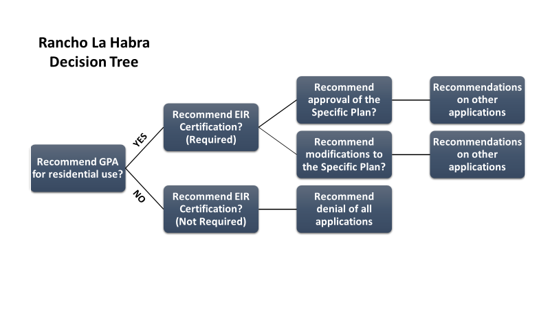
CONCLUSION
Staff recommends that the Commission consider all written and oral testimony and provide direction to bring back resolutions to:
- Recommend that the City Council approve/deny the General Plan Amendment.
- Recommend that the City Council certify/not certify the Final EIR
- Recommend that the City Council approve/deny amendment #3 to the La Habra Hills Specific Plan
- Recommend that the City Council adopt/not adopt Rancho La Habra Specific Plan
- Recommend that the City Council approve/not approve Zone Change 18-01 to adopt/not adopt the Rancho La Habra Specific Plan
- Recommend that the City Council approve/not approve Tentative Tract Map
- Recommend that the City Council approve/not approve Design Review
- Recommend that the City Council approve/not approve Development Agreement.
FISCAL IMPACT/SOURCE
Refer to fiscal analysis discussion above.
NATIONAL POLLUTANT DISCHARGE ELIMINATION SYSTEM (NPDES):
The Applicant’s proposal has been reviewed pursuant to the requirements of the City’s National Pollutant Discharge Elimination System (NPDES) Municipal Permit, the Local Implementation Plan (LIP), and the Model Water Quality Management Plan (WQMP), Section 7.2. Since the proposal will constitute the disturbance of more than 5,000 square feet of soil, a Priority WQMP is required. A Preliminary Priority WQMP has been approved and included within the Environmental Impact Report (see Appendix “O” of the Environmental Impact Report).
CALIFORNIA ENVIRONMENTAL QUALITY ACT (CEQA):
An Environmental Impact Report was prepared pursuant to the CEQA Guidelines. A Scoping Meeting was held on December 8, 2015, at the La Habra Community Center to solicit information and comments from interested parties on what information or areas of study should be included in the initial study.
The Draft Environmental Impact Report was circulated for public review and comment on February 26, 2018, for a 45-day review period pursuant to Section 15072 of the CEQA Guidelines, which was extended by the City Council to end on May 10, 2018, Potential impacts identified and analyzed in the Draft EIR included:
Land Use and Planning
Population and Housing
Aesthetic Resources
Biological Resources
Cultural Resources
Traffic and Circulation
Air Quality
Greenhouse Gas Emissions
Energy Resources
Noise and Vibration
Hazards and Hazardous Materials
Hydrology and Water Quality
Geology, Soils, and Seismicity
Public Services
Recreation
Utilities, Service Systems, and Water Supply
Copies of the reports were made available at the Community Development public counter at City Hall, on the City website, and at the La Habra Branch of the Orange County Library system. The City received 141 comments on the Draft EIR from state and local agencies, tribal authorities, interest groups, and the public. Pursuant to the provisions of the (CEQA) Guidelines, Section 15088.5(a), the City determined that a thorough response to the comments received by the City during the public review period necessitated the inclusion of significant new information.
The City circulated the “Partially Recirculated Draft EIR” for a 57-day review period beginning on November 22, 2019 and ending on January 17, 2020. Upon completion of the review period for the Partially Recirculated Draft EIR, the City of La Habra prepared responses to written comments that were received on the Draft EIR during the initial public review period as well as written comments received during the recirculation period that relate to the revised and recirculated portions of the Partially Recirculated Draft EIR. The Final Draft EIR including the revised technical studies, and responses to the comments were made available to the public for review on July 7, 2020 (see attachment 2. Rancho La Habra Specific Plan Final Environmental Impact report Volumes 1, 2 and 3).
GENERAL PLAN RELEVANCE/CITY COUNCIL GOALS & OBJECTIVES:
Refer to General Plan Amendment discussion above.
Attachments
- FEIR Vol 1
- FEIR Vol 2
- FEIR Vol 3
- FEIR VOl 1 and 2 Replacement pages
- FEIR Appendix A
- FEIR Appendix B
- Revised Appendix A
- FEIR Appendix C
- Revised Appendix C
- FEIR Appendix D & E
- FEIR Appendix F
- FEIR Appendix G
- FEIR Appendix H
- FEIR Appendix I
- FEIR Appendix J
- FEIR Appendix K
- FEIR Appendix L
- FEIR Appendix M
- FEIR Appendix N
- FEIR Appendix O
- FEIR Appendix P
- FEIR Appendix Q
- FEIR Appendix R
- FEIR Appendix S
- FEIR Appendix T
- Project Design Plans
- Development Agreement
- City Wide Notice
- Property Owner Notice
- Letters of Support for the Project
- Letters of Opposition to the Project
- PowerPoint
- PC Resolution No. 20-31
- PC Resolution No. 20-32